
- Top
- Notice
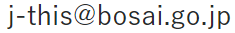
- Show Tsunami Hazard Information on Map
- Nankai Trough (Earthquake Research Committee,ver 2020)
- Introduction
- User Manual
- Glossary
- Term and conditions
- FAQ
- Documents
- Web API
-
J-THIS Labs
- Contact information
-
3-1 Tennohdai, Tsukuba-shi, Ibaraki 305-0006, Japan
National Research Institute for Earth Science and Disaster Resilience (NIED)
Department of Catastrophic Geohazard Research
Research Division for Earthquake, Tsunami, and Multi-disasters
Person in charge of J-THIS
-
3-1 Tennohdai, Tsukuba-shi, Ibaraki 305-0006, Japan
Overview
The National Research Institute for Earth Science and Disaster Resilience (NIED) has been conducting a nation-wide probabilistic tsunami hazard assessment (PTHA) since 2012 for the aim of preparing and counter-measuring to tsunamis, caused by earthquakes, based on the lessons learned from the tsunami damage caused by the 2011 off the Pacific coast of Tohoku earthquake.
In addition, a committee of experts, called "Committee on the Utilization of Tsunami Hazard Information (2013-2016)" was established so that the results of PTHA will contribute possible disaster reduction. This committee has been discussing (1) the needs of beneficiary who utilize tsunami hazard information, (2) the contents of information that should be provided to meet those needs, and (3) the specific possibilities for utilization. In the recommendations compiled by this committee, the necessity of a publicly available system that allows experts who conduct tsunami risk assessment and others to utilize diverse tsunami hazard information was emphasized.
Based on these discussion, the J-THIS (Japan Tsunami Hazard Information Station) was developed to contribute to the utilization of various tsunami hazard information, thus to tsunami disaster prevention.
News
J-THIS Labs
Technical Note of the National Research Institute for Earth Science and Disaster Resilience No.439
Probabilistic Tsunami Hazard Assessment for Earthquakes Occurring along the Nankai Trough ‒ Volume 1 Part I
Evaluation reference date 2024/1/1
Evaluation reference date 2023/1/1
Evaluation reference date 2022/1/1
Technical Note of the National Research Institute for Earth Science and Disaster Resilience No.439
Probabilistic Tsunami Hazard Assessment for Earthquakes Occurring along the Nankai Trough ‒ Volume 1 Part II
Evaluation reference date 2024/1/1
Evaluation reference date 2023/1/1
Introduction
An overview of the probabilistic tsunami hazard assessment
J-THIS (Japan Tsunami Hazard Information Station) publishes probabilistic tsunami hazard assessment results that are equivalent to the publicly disclosed contents of the "Probabilistic Tsunami Hazard Assessment due to Large Earthquakes along the Nankai Trough" (Earthquake Research Committee, 2020) in Japan.
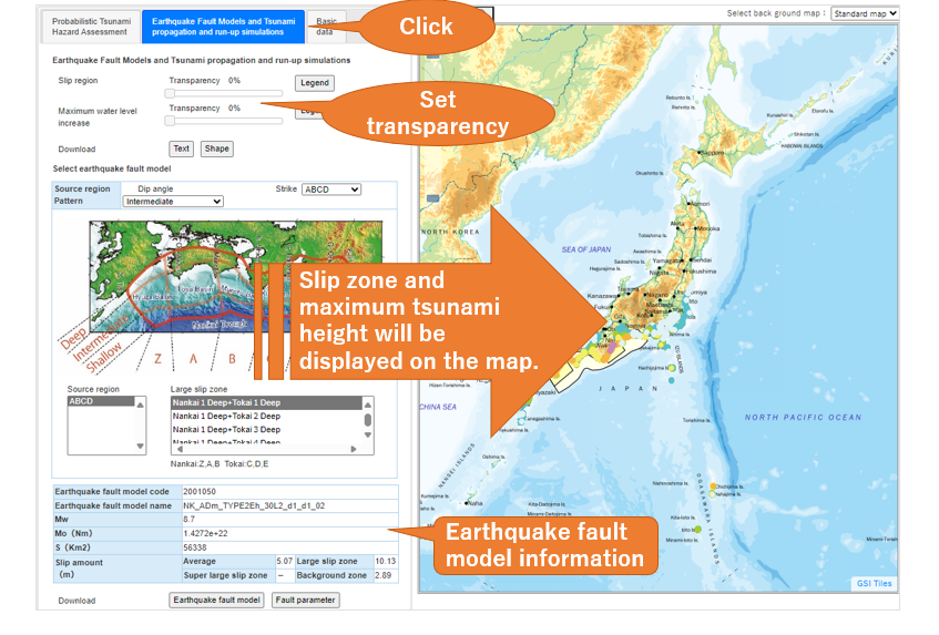
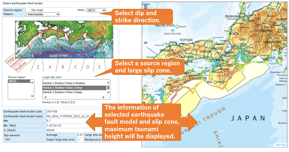
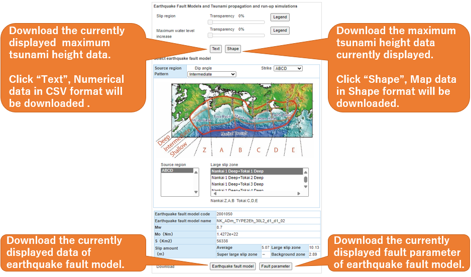
Based on the "Long-term Evaluation of seismic activity along the Nankai Trough, Second Edition" (Earthquake Research Committee, 2013), the Earthquake Research Committee constructed a group of fault models (characterized earthquake fault models) that represent a variety of interplate earthquakes with different magnitudes and slip heterogeneity. The slip heterogeneity of the characterized earthquake fault model is expressed by giving two types of slip regions, one with twice the average slip and the other with a background slip. The characterized earthquake fault models were constructed based on the "Tsunami recipe," which is a method for predicting tsunamis by characterizing the earthquake fault (Earthquake Research Committee, 2017). The characterized earthquake fault models covered earthquakes with magnitudes from M8 class to sub-M9 class.
In the past, both Nankai and Tonankai earthquakes have occurred in close timing and spatial proximity along the Nankai Trough. Therefore, instead of evaluating only one large earthquake, the evaluation was made to consider the possibility that multiple large earthquakes may occur in close time-space proximity during one cycle of the Nankai and Tonankai earthquake activity. To express a variety of earthquake ruptures, a large number of combinations of earthquake faults that could occur during one cycle of the Nankai and Tonankai earthquake activity have been set in the evaluation.
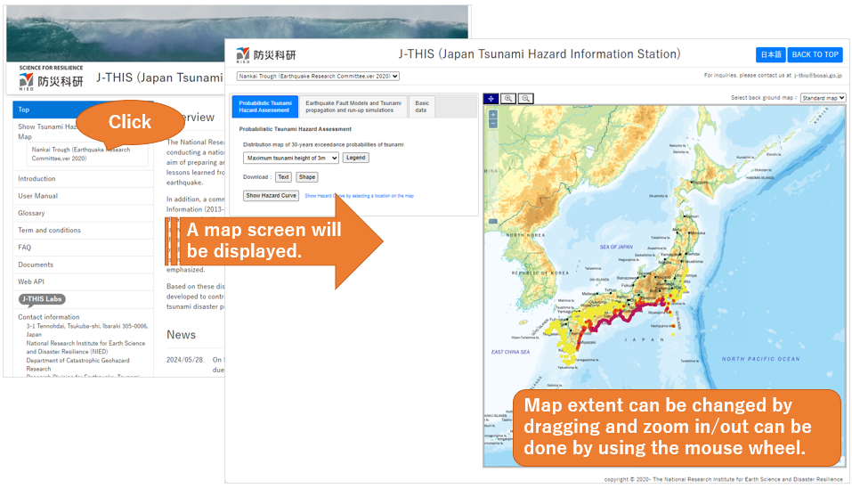
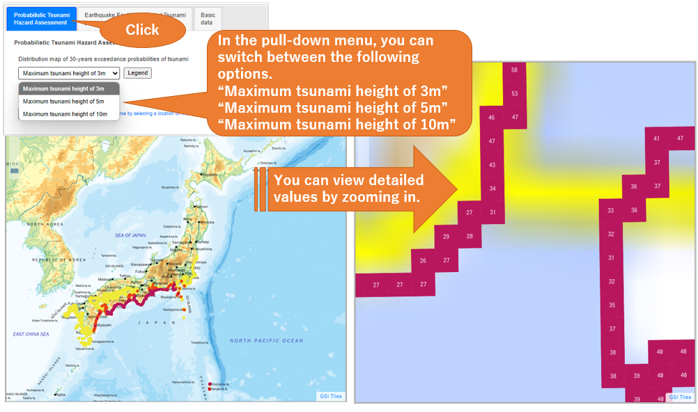
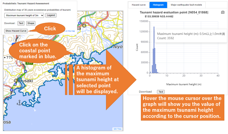
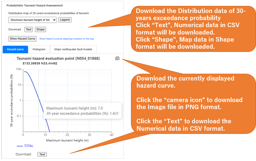
J-THIS estimates probabilistic tsunami hazard curves at over several hundreds of thousands of evaluation points along the coastline (shoreline). Based on the estimated hazard curves, the J-THIS creates and publishes a distribution map of 30-years exceedance probabilities, which probabilistically predicts the likelihood of a tsunami occurring and hitting a specific coastal area facing the Pacific Ocean along the Nankai Trough. This map can show which coastal areas are relatively more or less likely to be hit by a tsunami compared to other areas.
User Manual
※As of 2023/12/11, we are showing only the contents from Technical Note No 439 Volume 1 Part Ⅱ
※As of 2023/12/11, we are showing the contents from Technical Note No 439 Volume 1 Part Ⅱ
Glossary
| Glossary | Explanation |
|---|---|
| Maximum tsunami height | The amount of water level rise at a specific location. It is obtained by subtracting the ground deformation due to earthquake from the maximum water level measured from Tokyo Peil (T.P.). |
| Distribution map of maximum tsunami height | Distribution map of the maximum tsunami height (Strictly speaking, it means "maximum water level rise") at multiple hazard evaluation points defined along the coastline. |
| Source region | Area ruptured by earthquakes. The 18 region elements on the upper boundary of the subducting Philippine Sea Plate along the Nankai Trough were set based on "Long-Term Evaluation of seismic activity of the Nankai Trough, Second Edition" (Earthquake Research Committee, 2013). Any arbitrary earthquake source region can be represented by a combination of adjacent region elements. |
| Source region pattern | The combination patterns of earthquake source regions. |
| Distribution map of Exceedance probability | A distribution map of estimated exceedance probabilities for a large number of hazard evaluation points defined along the coastline. |
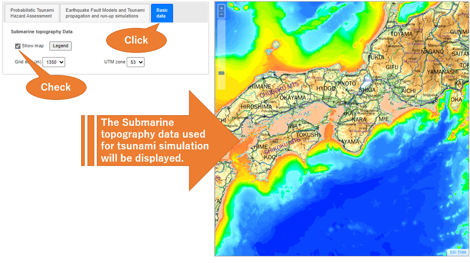
| Tsunami propagation and run-up simulation | Tsunami propagation and run-up simulations was performed by solving the non-linear long wave equation derived from the equation of motion and the equation of the continuity using a finite difference method. |
| Earthquake fault model | When the location and geometry of the fault plane are given, and the heterogeneity of the fault slip is specified, it is called an 'earthquake fault model'. Note that source regions, namely those only the location and geometry of the fault plane are specified, are not earthquake fault models. |
| Characterized earthquake fault model | An earthquake fault model with characterized fault slip heterogeneity is called a 'characterized earthquake fault model'. |
| Tsunami hazard evaluation point | Mesh along coastline which tsunami hazard are evaluated |
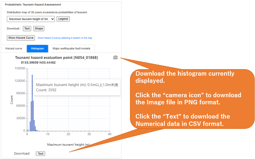
| Histogram of maximum tsunami height | A graph that classifies the frequency of maximum tsunami height used in probabilistic tsunami hazard assessment into 0.5-meter intervals. It contains the total number of combinations of earthquake fault models that make up the earthquake source region pattern. |
Term and conditions
-
Article 1: Application of agreements
- 1.J-THIS (Japan Tsunami Hazard Information Station) agreements (hereinafter referred to as "agreements") applies to the usage of the J-THIS, an information service provided by the National Research Institute for Earth Science and Disaster Resilience (hereinafter referred to as "NIED") through its website, as well as the articles, headlines, charts, photographs (collectively referred to as "contents" below), and data provided by the J-THIS.
- 2.In addition to agreements, the terms and conditions, and other regulations (hereinafter referred to as "regulations") established separately by NIED shall be considered as part of agreements.
- 3.If the provisions of this agreements and the contents of the regulations in the preceding paragraph are different, the contents of the regulations shall take precedence and be applied.
-
Article 2: Revision of agreements
- 1.NIED may change agreements at any time without prior notice. In this case, the terms and conditions of the J-THIS shall be based on the revised agreements.
- 2.Except as otherwise provided by NIED, the revised agreements shall become effective from the time it is displayed on the J-THIS website.
-
Article 3:Confirmation of data
- 1.Tsunami hazard assessment data were produced based on the research products of NIED
- 2.The tsunami hazard assessment data were produced in a given period, e.g., in the 30 years after the reference date.
- 3.The displayed information may differ from an actual case (e.g. railroad, road, administrative district, etc.).
-
4.Data have been carefully checked. However, if you found any mistakes, please contact us at【】if you have any questions.
-
Article 4: Matters to be included upon reproduced or cited
- 1.Please acknowledge it clearly if data from tsunami hazard assessment data are reprinted or quoted for any purpose.
-
2.If academic papers, reports, etc. are created and printed materials are published or produced using the tsunami hazard evaluation data, please send a copy to the address below. This includes preprints of scientific meetings, etc.
3-1 Tennohdai, Tsukuba-shi, Ibaraki 305-0006, Japan
National Research Institute for Earth Science and Disaster Resilience (NIED)
Department of Catastrophic Geohazard Research
Research Division for Earthquake, Tsunami, and Multi-disasters
Person in charge of the J-THIS
- 3.If the contents are reproduced or cited, user should write a note showing that the source is this website.
-
Article 5: Limitations on Use
-
1. Users can edit and process data from the tsunami hazard assessment data, and distribute, transfer, and/or loan the results freely, except in the restrictive cases stipulated in Article 5. If, however, users plan to sell the results, they are required to contact【】. An application may be required.
- 2.Users are prohibited from duplicating data from the tsunami hazard assessment data (including duplication in a different file format), and from distributing and transferring data to a third party.
- 3. Users are prohibited from using data from the tsunami hazard assessment data for purposes that violate any law. Use of this data for purposes, by means, and in ways that infringe on others' rights and offend public order and morals are also prohibited.
- 4.Should the above restrictive items be violated, any use of data from the tsunami hazard assessment data is strictly prohibited.
-
1. Users can edit and process data from the tsunami hazard assessment data, and distribute, transfer, and/or loan the results freely, except in the restrictive cases stipulated in Article 5. If, however, users plan to sell the results, they are required to contact【
-
Article 6: Service contents
- 1.Data from the tsunami hazard assessment data can be downloaded for free. However, the cost of communication fees for downloading, etc., will be borne by the user.
- 2.This website does not provide any software required to use the data.
-
Article 7: Disclaimers
- 1.Users take full responsibility for any damage that they, or third parties, incur in relation to the use of data, whatever the reason may be. Neither the Headquarters for Earthquake Research Promotion nor NIED is responsible for any damage resulting from the use of the tsunami hazard assessment data.
- 2.NIED takes no responsibility for any damage arising during access and download from the J-THIS.
- 3.The representation of the base map on the J-THIS does not represent the official views of NIED.
-
Article 8: Others
- 1.The laws of Japan govern the terms and conditions for this website.
-
2.Please contact【】for questions about this website.
FAQ
Documents
Reports by the Headquarters for Earthquake Research Promotion
Probabilistic Hazard Assessment of Tsunami due to Large Earthquakes along the Nankai Trough KeyPoints , Outline
Tsunami prediction method for earthquakes with characterized source faults (Tsunami Recipe)
Long-term Evaluation of seismic activity along the Nankai Trough (second edition) (In Japanese)
Technical Note of the National Research Institute for Earth Science and Disaster Resilience (In Japanese)
No.439
Probabilistic Tsunami Hazard Assessment for Earthquakes Occurring along the Nankai Trough - Volume 1 Part I Chapter1-4| Chapter5-7| Chapter8-9| Chapter10-12| Appendix
Probabilistic Tsunami Hazard Assessment for Earthquakes Occurring along the Nankai Trough - Volume 1 Part Ⅱ Chapter1-4| Chapter5-7| Chapter8-9| Chapter10-12| Appendix